Miner -
Here's some interesting information on the Zanclean megaflood, which may have washed all the way to the eastern Mediterranean from the Straits of Gibraltar.
Geological and geophysical data identifies an extensive, buried and chaotic sedimentary body deposited in the western Ionian Basin after the massive Messinian salts and before the Plio-Quaternary open-marine sedimentary sequence. This body is consistent with the passage of a megaflood from the western to the eastern Mediterranean Sea via a south-eastern Sicilian gateway. Evidence for a large amplitude drawdown is provided in the Ionian Basin during the MSC (Messinian Salinity Crisis)*, support the scenario of a Mediterranean-wide catastrophic flood at the end of the MSC, and suggest that the identified sedimentary body is the largest known megaflood deposit on Earth.
Six million years ago the Mediterranean Sea was a very different place than it is today. Plate tectonics had closed the Strait of Gibraltar separating modern-day Spain and Morocco, leaving the Mediterranean cut off from the Atlantic Ocean. The newly enclosed sea succumbed to evaporation, its water level falling by thousands of meters, turning it into a desertlike environment pockmarked with shallow pools as salty as today’s Dead Sea.
One hypothesis suggests a megaflood rapidly refilled the Mediterranean. Now, a study of buried ocean sediments near Sicily shows this flood may have washed all the way into the sea’s partially filled eastern basin via a waterfall about 1,500 meters high.
Although floods have punctuated the Earth’s history, the “Zanclean megaflood”—so named for the geologic age during which it occurred (from 5.3 million to 3.6 million years ago)—is thought to be the largest ever, the new research, published in
Scientific Reportsreveals.
Garcia-Castellanos and his colleagues have successfully modelled the dynamics of the flood using new formulations based on how rivers change landscapes through incision — the water-driven erosion that cuts a path through rock (see
page 778). This idea to incorporate incision-based processes stems back to research Garcia-Castellanos did several years ago as a postdoc at the Free University in Amsterdam, where he studied tectonic lakes.
Unless an underlying tectonic process keeps them in place, Garcia-Castellanos explains, most lakes 'quickly' disappear — they fill up with sediment, overspill their banks and the water finds a way out, incising along an outlet. “In the models we were running in Amsterdam, this transition was very fast,” he says. At around the same time that he was doing his postdoctoral work he started to learn about the Messinian salinity crisis. It struck him that the feedback between water flow and incision should be similar in the Zanclean flood.
By combining a variation of the river-incision model with the proper hydrodynamic equations for the Zanclean flood, Garcia-Castellanos and colleagues predicted that although the initial stages of the flood may have taken thousands of years — with water trickling down a ramp of rock at the strait — 90% of the flood water was transferred to the Mediterranean basin in a period lasting between only a few months and two years. According to the authors' model, at peak discharge water poured in at a rate of 100 million cubic metres per second, cutting down into the bedrock by almost half a metre per day and possibly raising the level of the Mediterranean Sea by more than 10 metres per day.
By combining a variation of the river-incision model with the proper hydrodynamic equations for the Zanclean flood, Garcia-Castellanos and colleagues predicted that although the initial stages of the flood may have taken thousands of years — with water trickling down a ramp of rock at the strait — 90% of the flood water was transferred to the Mediterranean basin in a period lasting between only a few months and two years. According to the authors' model, at peak discharge water poured in at a rate of 100 million cubic metres per second, cutting down into the bedrock by almost half a metre per day and possibly raising the level of the Mediterranean Sea by more than 10 metres per day.
A new study, led by Aaron Micallef, a marine geologist at the University of Malta, found the sediments buried near Sicily were likely deposited by the megaflood—a finding that implies a violent influx of water throughout the Mediterranean. “A catastrophic event like the Zanclean megaflood would undoubtedly have left its mark in the sedimentary rock record,” says Lauren Shumaker, a geologist at the Colorado School of Mines, who was not involved in the research. “The authors have laid out some good evidence showing they may have found that mark.”
Micallef and his colleagues focused on the Malta Escarpment because megaflood water flowing east would have encountered this natural blockade, making it a logical place to find sediments deposited by water that breached the cliff. The researchers used seismic reflection imaging, which involves directing sound waves toward the sea bottom and measuring the time it takes them to return. Essentially an x-ray of the seafloor, this technique allowed the team to reconstruct the thickness and likely composition of buried sediment layers.
One of those layers stood out from the others; it was a jumbled mix of angular pebbles and boulders. “It doesn’t have internal layering like marine sediments normally do,” says Garcia-Castellanos, who was also a co-author of the new study. This irregularity implies the sediments—up to 800 meters thick in places—were laid down “quickly and haphazardly,” Micallef says, consistent with the material being transported by rushing water. Furthermore, this layer lay just to the east of Noto Canyon, a large undersea gorge running through the Malta Escarpment. The canyon bears a curious geologic scar on its western side; a channel 400 meters deep runs through its hard limestone. This feature, similar to the signatures of erosion seen near the Strait of Gibraltar, was probably caused by flowing water, the researchers reasoned. “We think we found this breach just to the southeast of Sicily,” Micallef says.
These findings build on the 2009
Nature study, which showed water violently rushed into the desiccated Mediterranean after shifting tectonic plates reopened the Strait of Gibraltar. The deluge carved a 200-kilometer-long channel along the seafloor as it filled the western part of the Mediterranean basin.
The scientists estimated water coursed over the escarpment through Noto Canyon, flowing at up to 160 kilometers per hour and spilling over a 1.5-kilometer-high waterfall into the Mediterranean’s briny eastern basin. Micallef and his team have hypothesized, based on earlier calculations by Garcia-Castellanos and his colleagues, that the torrent boosted the sea level in the eastern Mediterranean by at least 10 meters per day, refilling the entire sea in just a few years.
 Gateway for the passage of the Zanclean flood to the eastern Mediterranean. (a) Shaded relief model of south-eastern Sicily showing terrestrial chaotic Zanclean deposits, and seafloor slope gradient map showing Noto Canyon. Isobaths denoted by dotted red lines. Location in (e). (b) Seismic reflection profile CIR-07 showing Noto Canyon head and Messinian erosional surface upslope. Location in (a). Interpretation is based on correlation with nearby wells (shown in (e)). (c) Photograph of terrestrial chaotic Zanclean deposits. Location in (a). (d) Seismic reflection profile C-578, located upslope of Noto Canyon, showing a channel eroded in pre-Messinian limestones. Channel fill is marked by large-scale downlap and sigmoidal internal configuration (denoted by yellow lines), suggesting infilling by high energy deposition, and is sealed by Plio-Quaternary muds. Interpretation and depth conversion based on well Rosa_001 (location in (a)). Un-interpreted profile in Supplementary Fig. S2. (e) Messinian topography (above and below present sea level) across south-east Sicily and Malta Plateau, generated using published seismic reflection profiles and well data (Supplementary Fig. S4), overlaid on shaded relief model of present bathymetry. Thickness of Messinian evaporites from well data is included. Potential flow paths of the Zanclean flood are indicated by red arrows (solid = likely; dashed = unlikely). Extent of unit 2 is outlined in orange. Dashed black lines denote boundaries of graben structures. Maps generated with ArcMap 10.2 (http://www.esri.com/arcgis/). Background data from a recent compilation39 and EMODnet bathymetry (www.emodnet-bathymetry.eu/).
 Seismic stratigraphy of western Ionian Basin. Interpreted units on (a) PSDM seismic reflection profile CROP 21 and (b) post-stack time-migrated seismic reflection profile CUMECS-3. A plot of estimated PSDM seismic velocities is included in (a). Location of profiles in Fig. 2a. Correlation with DSDP Site 374 (location in Fig. 2a) is provided for (b). Dashed black lines denote inferred faults. CDP = common depth point; SP = shot point. Unit 1 consists of high amplitude, continuous, parallel to sub-parallel reflectors, which correlate with Pliocene-Quaternary pelagics, contourites and turbidites (Supplementary Table S1). In (b), the shallower section of unit 1 is shaped into sediment waves. Unit 3 correlates with MSC evaporites (Supplementary Table S1) and comprises a discontinuous, highly reflective and mostly deformed upper unit (3a - gypsum and marls), an intermediate, typically reflector-less unit with a basin-fill geometry (3b - halite), and a lower, highly reflective, discontinuous unit (3c - lower gypsum or clastics). The top of unit 3 slopes towards the south-south-east. Unit 2 is described in the text. In (b), unit 2 is imaged at a transition from a chaotic to laminated seismic facies.

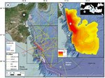
Location and geometry of unit 2. (a) Bathymetric map of the eastern Sicily Channel and western Ionian Basin, and location of analysed seismic reflection profiles. Location of DSDP Site 37413 is denoted. 1: Mt Etna; 2: Catania Plain; 3: Hyblean Plateau; 4: Malta Plateau; 5: Calabrian accretionary wedge; 6: Sicilian Fold and Thrust Belt. (b) Isopach map of unit 2 based on 2.3/2.6 km s−1 PSDM seismic velocities (contour interval of 150/172 m). 7: Malta Escarpment; 8: Noto Canyon; 9: Alfeo Seamount; 10: Depocentre of unit 2. Inset: Location of (a) in the Mediterranean Sea. 11: Straits of Gibraltar; 12: Alborán Sea. Maps generated with ArcMap 10.2 (http://www.esri.com/arcgis/). Background data from a recent compilation39, EMODnet bathymetry (www.emodnet-bathymetry.eu/), and a compilation of data from ESRI, DigitalGlobe, GeoEye, Earthstar Geographics, CNES Airbus DS, USDA, USGS, AeroGRID, and IGN.
It is difficult to imagine this environmental transition, Garcia-Castellanos says. “We don’t have present-day analogues.” These rapid changes probably affected the local climate and the circulation of Atlantic seawater, Micallef and his team propose.
The Zanclean megaflood clearly altered a wide swath of the planet’s surface, but may not be unprecedented, says Garcia-Castellanos. Other large ocean basins have probably closed and reopened five or six times in Earth’s history, and will likely do so in future, he says. “In a few million years the Mediterranean will probably separate again from the Atlantic.”
See:
https://www.scientificamerican.com/...h-waterfall-refilled-the-mediterranean-video/
See:
https://www.nature.com/articles/7274697a
* Messinian Salinity Crisis (MSC) - was an outstanding palaeo-oceanographic event that affected the Mediterranean region from 5.97 to 5.33 Ma. A temporary restriction of the Atlantic-Mediterranean seaway at Gibraltar induced an imbalance between evaporation and water inputs, transforming the Mediterranean Sea into a giant hypersaline lake and resulting in the deposition of kilometre-thick sequences of salts. A widespread interpretation involves the partial desiccation of the Mediterranean Sea during the Messinian, with proposed sea level drawdowns of 1300–2400 m
See:
https://www.nature.com/articles/s41598-018-19446-3
Based on a combination of geological and geophysical data, the Zanclean megaflood flowed from the western Mediterranean at the Gibraltar Straits, when a passage for the seawater was created by tectonic and geophysical processes, to the eastern Mediterranean via a gateway located in south-eastern Sicily. The deposited salt from the MSC and the later silt and fluvial deposits from the megaflood seem to support this theory by a predominance of evidence.
Hartmann352